
Must Do Hiking Trails of Martha’s Vineyard
 |
|
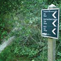
Trail Maps Rentals |
The natural beauty of Martha’s Vineyard has long encouraged both conservation and sustainable development. In fact, mandates of several Island organizations, including the MV Landbank Commission and the Trustees of Reservations focus on the acquisition of undeveloped land to be held aside for public use. MVOL.com invites you to visit, explore and enjoy these natural resources, perhaps starting with these four reservations perfect for springtime exploration.
A Short Afternoon Stroll – Priester’s Pond
At this small and easily accessed Land Bank property you’ll find two relaxing and shaded paths that crisscross through Beetlebung trees, providing homes to ospreys, kingfishers and many Vineyard songbirds. The highlight site is Priester’s Pond which can be especially beautiful in the early evening and around sunset.
- 6 Acres.
- Leashes are required for dogs April 15 – August 15
- Located at the intersection of North Rd and State Rd. in Chilmark.
A Walk through Vineyard History – Waskosim’s Rock
Just a short trip up the road from Priester’s Pond is Waskosim’s Rock Reservation. Straddling the West Tisbury – Chilmark line, it offers very fine scenic trails. Discover ancient stonewalls and stunning views of Fisher Pond. Follow the green trail to find Waskosim’s Rock, a historical marker for the “middle line” separating Wampanoag land from that of the settlers.
- 185 Acres.
- Find mountain biking, picnicking, hunting and equestrian access.
- Located off of North Rd just west of the West Tisbury / Chilmark Line.
A Beach Adventure – Cape Poge Wildlife Refuge
Hugging the entire eastern shore of Martha’s Vineyard is the massive Cape Poge Wildlife Refuge. The refuge extends from Wasque Point to the south all the way northward to Cape Poge. The ideal access to this reserve is by oversand exploration by truck (permit required) but certain areas are also reachable by car and bicycle. There are over 14 miles of hiking trails, some considered moderately difficult, but all extremely scenic, offering commanding views of the Atlantic Ocean or Nantucket Sound. Over sand tours are available during the summer season.
- 516 Acres
- Find fishing, hiking, picnicking, swimming, beaches, hunting and off-roading.
- Accessible by Chappaquiddick Rd or Wasque Rd on Chappaquiddick.
The Jewel of Martha’s Vineyard – Menemsha Hills Reservation
Prospect Hill (MV’s second highest peak) is home to Menemsha Hills reservation. Managed by the Trustees of Reservations, it is a great destination for anyone looking for a fun way of getting back in touch with nature. Harris Trail loops around low lying wetlands, home to red maple, cinquefoil, beech and black cherry trees, before giving way to brushy bushes and grasses. Here cool breezes blow from Vineyard Sound and a path leads down to the rocky beach below. Commanding views of Menemsha Village and the Elizabeth Islands lie before you and excellent flora and fauna opportunities await. Give at least 3 hours for the hike.
- 211 Acres
- Find fishing, hiking, picnicking, beaches.
- Follow North Rd. to Menemsha and parking is about 3/4 a mile before Menemsha Crossroads